
УДК 332.144
ИНТЕЛЛЕКТУАЛЬНОЕ УПРАВЛЕНИЕ ЗЕМЕЛЬНЫМИ РЕСУРСАМИ – ПРАКТИЧЕСКОЕ ПРИМЕНЕНИЕ И РАЗВИТИЕ
SMART LAND MANAGEMENT — PRACTICAL APPLICATIONS AND DEVELOPMENT
Нгуен Ван Тхинь, магистрант ФГБОУ ВО «Государственный университет по землеустройству», г. Москва
Нилиповский Василий Иванович, научный руководитель, проректор по международному сотрудничеству, ФГБОУ ВО«Государственный университет по землеустройству», г. Москва
Nilipovskiy V.I., info@guz.ru
Van Thinh Nguyen, binhant1990@gmail.com
Аннотация. Интеллектуальное управление земельными ресурсами является тенденцией к улучшению и повышению эффективности ряда стандартов в области управления земельными ресурсами и земельными базами данных. Как и «умная жизнь», развитие технологий в управлении земельными ресурсами также очень важно, особенно в эпоху цифровых технологий, потому что земля является чрезвычайно ценным ресурсом. Для всех видов производственной деятельности, деятельности человека и промышленности требуются земельные участки. Применение информационных технологий в области управления земельными ресурсами во Вьетнаме достигло определенных конкретных достижений, но все еще есть много недостатков, требующих долгосрочной стратегии с конкретными целями и методами. Для того, чтобы иметь современную и гладкую модель базы данных о земле от центрального до местного уровней и один из основных инструментов для управления и применения информационных технологий управления земельными ресурсами.
Summary. Smart land management is a trend to improve and improve the efficiency of a number of standards in land administration and land databases. Like “smart life,” technology development in land management is also very important, especially in the digital age, because land is an extremely valuable resource. For all types of production activities, human activities and industry requires land. The application of information technology in the field of land management in Vietnam has achieved some specific achievements, but there are still many shortcomings, requiring a long-term strategy with specific goals and methods. In order to have a modern and smooth model of land database from central to local levels and one of the main tools for management and application of land management information technology.
Ключевые слова: интеллектуальное землеустройство, Информационные технологии, цифровой кадастр; Геоинформация/GI; девелопмент недвижимости.
Key words: Smart Land Management, Information Technologies, Digital cadastre; Geoinformation/GI; Real estate development.
Solve synchronous management problems
At present, the application of information technology on land management and construction management in specialized management agencies in general has not been synchronously implemented. Most only apply informatics technology in a number of specific technical jobs or some stages in the operating link without being an operating and management system.
Moreover, application software in the industry is discrete tools, each software only supports a part of the operation. The organization of record keeping is mainly done manually by papers and books. Discrete management, lack of science, no support in dealing with administrative questions and answers, and not meeting the needs of general information analysis to serve leaders in management and run, do not have a complete database of land management — construction management for the management …
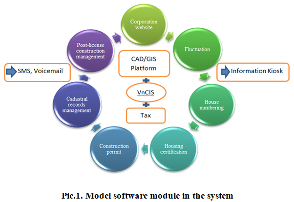
Stemming from such practical needs, in Vietnam, research, development and gradual improvement of «Land management information system based on GIS-VnCIS». The Land Management Information System version 1.5 was established, covering most of the land management operations built on three functions: Management application model, operational procedures, public administrative services and provide — look up information.
The software product suite of VnCIS information system version 1.5 is built based on the analysis of legal documents on land management, construction management, house and construction management, drawn from years of building individual products in the same field.
The construction land attribute data partitions and operational process data partitions are combined with the spatial data layer partition to form a unified land management GIS database. In the combined model of data partitions, the spatial data layer overlaps with the cadastral layer, and the attribute data layer corresponds to the spatial data through the land parcel geographic location.
The model of construction land management is organized according to 4 management levels: + The ministry-level specialized management at the central level.
+ Department of specialized management under the provincial / city People’s Committee.
+ Level of Specialized Management Division under District People’s Committee.
+ Land administration — construction division belongs to ward / commune People’s Committee.
Land management information system version 1.5 focused the management level as District People’s Committee with different management objects.
— Firstly, the system helps to link the construction management functions of the specialized units in association with the standardized one-stop receipt process. People apply at the one door department or at the People’s Committee of the commune / ward, the one door department (the cadastral department of the People’s Committee of the commune / ward) and transfer the dossier to the Urban Management Department (Division of Industry and Trade), Department of Land Administration The People’s Committee of the commune / ward manages the situation of house construction, construction violations in the area and reports to the Urban Management Division.
— Secondly, there is a link in land management function: people submit their application file at the OSS section or at the commune / ward People’s Committee, the OSS section will transfer the file to the Department of Natural Resources and Environment or the registration office. land use rights to process files, cadastral division Commune / Ward People’s Committee manages land use situation in the commune / ward and reports to Division of Natural Resources and Environment.
Since then, the VnCIS version 1.5 land management information system will help to review and standardize the full set of report forms, quickly adjust the handling processes when there is a change and create be modern working environment, transparent information. Reduce executive management time.
Potential wide application
The purpose of the system is to build a «one-stop service» working environment according to ISO processes in the field of construction land management, to minimize the time for document control and management, step by step standardization. chemical process operations contribute to administrative reform. At the same time, the system helps to build a complete GIS database, shared or shared in housing and construction management agencies from the ward / commune, district and Department of specialized management. and as a basis for later management of infrastructure works on land.
The system creates convenience and quickness in making periodic summary reports. There is sufficient information to analyze the situation of the processing of records, accurately identify the time delay period of each individual or department, helping leaders have appropriate and timely management. At the same time, it organized a model of scientific information storage, minimizing the time for searching information, improving the efficiency and quality of professional staff work.
The information system has a solid and flexible architecture in its implementation based on 3 systems: the management model, the operational process and the public administrative service “the key spirit of functional division”. The system provides a full range of functional tools for professionals in administration and operation. When there is a change in the process, the report form requires spatial data processing in the familiar GIS / CAD software environment.

Version 1.0 was built from 2001 to 2003. Following it, version 1.5 was completed from 6/2013 to 6/2015 and reached the final «Vietnam Talent Award 2018» in the real product category. has been applied.
Currently, VnCIS information system has been officially selected to be deployed in 6 provinces, especially some districts of Ho Chi Minh City, where population and land are relatively complicated. And is trying to expand the application of this utility product to other provinces, in order to contribute to simplifying public administrative procedures, saving time and effort for not only management levels but for each citizen.
To promote the development of smart land management trends, a number of control programs have been developed. Another problem is the increasing demand for better, stronger, smarter and cheaper solutions. Finally, the development of «intelligent land management» has and will bring new requirements and new rules around the world. Start of an era of modern technology in land management to serve human needs. Currently in Vietnam there is a lot of software for building cadastral files and cadastral databases, such as VILIS, ELIS or MTV-LIS. Most of the above software is fully exploited based on Enginer ESRI ArcGIS technology (this is a modern technology of the United States). Information technology is widely used in land management, especially cadastral record management. VnCIS software is a complete software for housing management and urban development to minimize search and information search, improve the efficiency and quality of work of professional staff, data security. There is sufficient information to analyze the situation of the processing of records, accurately identify the time delay period of each individual or department, helping leaders have appropriate and timely management. At the same time, it organized a model of storing scientific information, creating convenience and quickness in preparing periodic summary reports. It can also be exported in the form of an establishment in Vietnam. However, the disadvantage of most land management programs in Vietnam is the lack of communication between the products of applied information technology to form an information system. Weak graphic functions are not remedied, resulting in adjustment of changes in cadastral spatial data. There are still many difficulties that prevent managers from making changes in cadastral maps resulting in ineffective land management. In addition, bulky data storage can easily lead to duplication and difficult control. In such a situation, digital products need to be linked to land management into a single complete database. And VnCIS is a total solution for managing construction land with low cost, without paying copyright fees for the software tools attached to the system. The ultimate goal of every technological development is to improve the lives of everyone.
Literature
- Electronic resource. — Аccess mode: http://vbpl.vn/TW/Pages/vbpq-van-ban-goc.aspx?ItemID=25903
- Electronic resource. — Аccess mode: https://thuvienphapluat.vn/van-ban/Bat-dong-san/Thong-tu-04-2013-TT-BTNMT-quy-dinh-xay-dung-co-so-du-lieu-dat-dai-184591.aspx
- Electronic resource. — Аccess mode: https://www.fig.net/resources/proceedings/fig_proceedings/fig2019/papers/ts02j/TS02J_nilipovskiy_trung_thanh_et_al_10227_abs.pdf
- Electronic resource. — Аccess mode: https://thuvienphapluat.vn/van-ban/Bat-dong-san/Thong-tu-24-2014-TT-BTNMT-ho-so-dia-chinh-236560.aspx
- Electronic resource. — Аccess mode: https://thuvienphapluat.vn/van-ban/Bat-dong-san/Thong-tu-25-2014-TT-BTNMT-ban-do-dia-chinh-236562.aspx
- Electronic resource. — Аccess mode: https://dantri.com.vn/suc-manh-so/quan-ly-dat-dai-thoi-cong-nghe-so-1258573655.htmhttps://paradigm-interactions.com/smart-living-or-as-we-might-live-with-artificial-intelligence-and-the-iot-in-a-new-reality/
- Electronic resource. — Аccess mode: https://www.itri.org.tw/eng/Content/ MSGPic01/List1.aspx?SiteID=1&MmmID=620651706136357202